 Filter: Categories of Wisconsin Historical Images
Filter: Subject of United States. Army
Filter: Categories of Wisconsin Historical Images
Filter: Subject of United States. Army

| Date: | 1945 |
|---|---|
| Description: | Aerial view of the "powder storage area" of the Badger Ordnance Plant. |

| Date: | 12 21 1961 |
|---|---|
| Description: | Wisconsin's 32nd Division returns to Madison from Fort Lewis, Washington, on holiday leave. |

| Date: | 1931 |
|---|---|
| Description: | A topographical map from the U.S. Army Corp of Engineers showing the topography and man-made features in the Camp Williams area of the towns of Orange and ... |

| Date: | 1943 |
|---|---|
| Description: | United States Army poster with an illustration of four women posing in front of a U.S. flag. The women are wearing Army identification badges on their shir... |

| Date: | 1905 |
|---|---|
| Description: | This map shows a plat of the city, local streets, railroads, public buildings, local businesses, and parts of the Manitowoc River and Lake Michigan. Relief... |
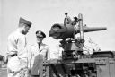
| Date: | 07 01 1961 |
|---|---|
| Description: | Lieutenant General Emerson L. Cummings, commanding general of the Fifth Army, talks with Private First Class John Rolfsmeyer of Madison at the dedication o... |

| Date: | 12 08 1961 |
|---|---|
| Description: | Col. John Roach, deputy state adjutant general, riding a motor scooter similar to the one being presented to his son, Capt. Pat Roach with the 32nd Divisio... |

| Date: | 1861 |
|---|---|
| Description: | Shaded drawings with size dimensions for plans of "Tents used in Civil War. U.S. Army Regulation Tents." Upper left, "18. ft diam, Gilbert Anderson Hub... |

| Date: | 1861 |
|---|---|
| Description: | Shaded drawings with size dimensions for plans of "Tents used in Civil War." Upper left, "18. ft diam 'SIBLEY' TENT." Upper right, "18. ft diam HASK... |

| Date: | 1865 |
|---|---|
| Description: | This map shows U.S. cavalry positions in yellow, Confederate infantry positions in blue, and Confederate cavalry positions in red. The map also shows roads... |

| Date: | 1960 |
|---|---|
| Description: | This map is a facsimile of a 1829 map and shows private land claims, landowners within military reserve boundaries, sawmill, Fort Howard, public barns, bri... |

| Date: | 04 11 1940 |
|---|---|
| Description: | This blue line print map shows survey monument markers by type and industrial buildings and covers part of the lower Fox River and East River. The map incl... |

| Date: | 04 1926 |
|---|---|
| Description: | This blueprint mostly shows various numbers within the canal and bay. Lake Michigan and Harobor of Refuge are shown along the far right side. Near the harb... |
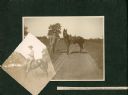
| Date: | 1900 |
|---|---|
| Description: | George W. Roskie (1876-?) poses with a horse in two photographs mounted in an album. The printed description reads: "G.W. Roskie, 1st Lieut 1st Reg Co K So... |
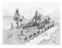
| Date: | 1998 |
|---|---|
| Description: | Drawing of Dr. Evermor's "Forevertron" envisioned on the site of the former Badger Army Ammunition Plant (originally known as Badger Ordnance Works). D... |
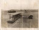
| Date: | 1918 |
|---|---|
| Description: | Elevated view of several men, most in military uniforms, inspecting a Lawson Air Liner outside a hangar at an airfield. The hangar door says 51st AERO SQDN... |
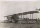
| Date: | 1918 |
|---|---|
| Description: | Three-quarter view from the right rear of a Lawson Air Liner. Several men in uniforms are standing near the airplane. Behind is a hangar with 51st AERO SQD... |
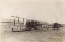
| Date: | 1918 |
|---|---|
| Description: | Three-quarter view from front left of a Lawson Air Liner parked in a field. Several men in uniforms are inspecting the plane. |
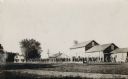
| Date: | 1909 |
|---|---|
| Description: | View across road and grass towards a group of soldiers marching through a Fox Lake neighborhood. |
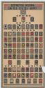
| Date: | 1920 |
|---|---|
| Description: | Poster featuring the insignia for all armies, corps, divisions, and special units of the United States Army during World War I. |
If you didn't find the material you searched for, our Library Reference Staff can help.
Call our reference desk at 608-264-6535 or email us at: